

American Everyman
by Scott Creighton
UPDATE:
Despite making many claims about the cause of the crash, the U.S. has refused to share the hardest evidence of all: the satellite imagery immediately prior, immediately after and, if available, at the moment of the attack and the downing of MH17.
Both Russian and American satellites have been surveilling the area of the fighting between the rebels and the Ukrainian military as well as the groups referred to by Ukrainian President Petro Poroshenko as “partisans.” With this deadly proxy war between Russia and the United States, it seems only logical that the U.S. intelligence community had its eyes on the area. If not, the CIA should go on record unequivocally stating that it has no satellite information of the area on the day in question…
… Why has the United States not released its satellite images of the time of the MH17 crash and, more importantly, moments prior to it? TruthDig
UPDATE: Hi-res Photo of Supposed Flight MH17 Shoot-down
As a follow-up to my earlier article about the new satellite photo which supposedly shows the moment a Ukrainian fighter jet launching an air-to-air missile at Flight MH17, I decided to see if I could locate the area in the background of the photo in the Ukrainian countryside via Google Earth. I have done that and found the photo does indeed match-up with the flight path Flight MH17 was on as well as the debris field located just 25 miles from where it was in the photo.
Here is the original photo supposedly leaked to a Russian news agency (click on photos for larger views).
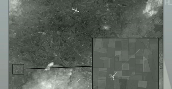
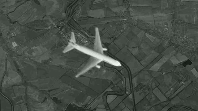
Here is a close up of what is claimed to be Flight MH17 as the air-to-air missile is launched.
This is a screen grab from Google Earth looking at Ukraine.

As you can see, the topography, the roads, even the land plots are the same. That is definitely the location where the plane was supposedly flying at the moment the air-to-air missile was fired, if indeed the image is not a hoax.
Using that location and again, Google Earth, I located the crash site in relation to the image. It’s about 25 miles on the exact same heading Flight MH17 is pictured on.
 Again, I’m not sure this image isn’t a hoax. But if it is, someone did their homework.
This trajectory is also consistent with the newly released radar data that shows how Flight MH17 approached it’s final resting place. The purple line is Flight MH17.

Here is another graphic showing the flight path and the location of the crash.

Like I said, I’m not sure this image is anything other than a hoax, but there is the information all the same.
